
The Florida Fish and Wildlife Conservation Commission is using a Google Maps application to gather basic information about the locations of fox squirrels in that state. Fox squirrel distribution is patchy, and there hasn’t been a distribution survey since 1997.
University of Florida wildlife ecology graduate student Courtney Hooker, who is overseeing the survey, was inspired by another Google Maps application that she had used herself: The South Carolina-based Center for Birds of Prey’s swallow-tailed kite project.
Hooker says the fox squirrel application has worked well since going on line in August 2011. “Most people are familiar with Google Maps, since they use it to get directions,” she says. The project has received over 600 reports so far, and has received a lot of media coverage.
Although the directions for logging a fox squirrel sighting on the site is only three short steps, Hooker says that she may make them even shorter and simpler. Many people aren’t reading them. Also, she prefers the way the swallow-tailed kite map allows users to right-click on the location they saw the bird. The fox squirrel map asks users to drag a red balloon to the site, which is a little confusing.
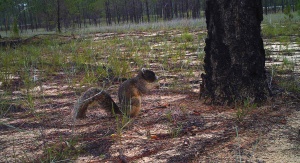
Hooker says that part of the success of the project is due to the fact that the fox squirrel, which is twice the size of the familiar gray squirrel, is such a striking species. “It’s an identifiable species and it’s a beautiful species. People tend to remember it.”
One of the few questions on the sighting form ask if the observer is a wildlife professional or not. Hooker was curious to see if a particular group was more responsive to the survey. So far, she says, about 95 percent of the respondents have been citizen scientists.
Many of the reports have been acommpanied by photos, she says, so Hooker has been able to confirm that they are indeed fox squirrels and not another species.
Hooker says that while the project is expected to help state biologists better understand the distribution of the fox squirrel throughout Florida, it’s also helped educate the public. “Some people have said that they had never seen one before.”
The Florida Wildlife Commission press release.
An article from TampaBay.com
And another article from Florida Today.
Photo: Fox squirrel, courtesy of Florida Fish and Wildlife Conservation Commission.
Pingback: Got Mink? | State Wildlife Research News
Pingback: Mapping Bears in Florida | State Wildlife Research News
Pingback: Mapping Bears in Florida | State Wildlife Research News