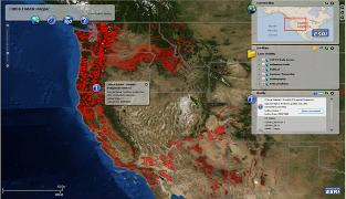
 Is a picture worth a thousand words? The US Fish and Wildlife Service and the National Oceanic and Atmospheric Administration (NOAA) think a map is worth several pages of text. Both governmental entities are planning on replacing the long written descriptions of critical habitat for Endangered Species Act (ESA) listings in the Federal Register with a map. Make that an on-line map.
The US Fish and Wildlife Service says that the map will be an easier way to describe an area. Up until now, the areas have been described in the Federal Register like this:
Land bounded by the following UTM Zone 18, NAD 83 coordinates (E,N): 733143, 99288; 733053, 99268; 733055, 99291; 733065, 99309; 733055, 99320; 733048, 99344; 733053, 99364; 733090, 99377; 733140, 99370; 733143, 99288.
While surely no one will miss that kind of prose style, providing a link instead of including all the necessary information in the Federal Register notice will mean that the vital information about the listing will not be in one place, which was always at least part of the point of the Federal Register. It’s also easy to imagine maps being created in formats that become obsolete or the funding for maintain the database getting cut.
The change takes effect on May 31, 2012. All ESA listings after that date will include a link to an on-line map instead of a written description.
Read the US Fish and Wildlife Service press release here.
It will send you to this web page on Critical Habitat for more information.
That page will send you to this example of an on-line map designating critical habitat.
Photo: The US Fish and Wildlife Service’s Critical Habitat Portal
